Key moments
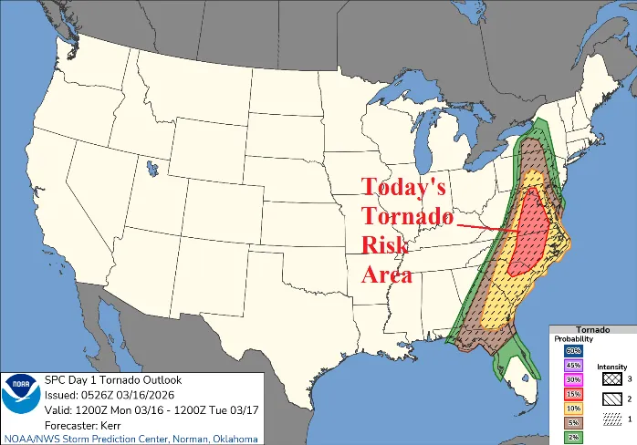
Severe weather is set to impact the East U.S. on March 16, 2026, with the National Weather Service issuing alerts for potential tornadoes and damaging winds. A squall line is currently moving eastward across the Ohio Valley, posing a significant tornado risk particularly for Mississippi and Alabama.
High wind advisories are widespread, with potential gusts reaching 60-70 mph in New England. In Brunswick County, severe thunderstorms are anticipated, with damaging wind gusts, tornadoes, and large hail possible. Residents are urged to prepare for severe conditions as the weather develops.
A Tornado Watch remains in effect until 4:00 AM CDT for central and west central Alabama, with Severe Thunderstorm Warnings issued for multiple counties in the state. Wind gusts of up to 60 mph are expected with these severe thunderstorms, and gusts of 45 mph are anticipated outside of thunderstorms in Brunswick County.
The severe weather episode is influenced by a recent cold front and record warmth in the West, creating conditions ripe for severe thunderstorms and tornado activity. The Midwest is also dealing with a blizzard, which is expected to wind down after an additional 5-15 inches of snow.
The PJM 15-day forecast indicates that after this storm, two additional chilly bursts are expected, further complicating the weather situation across the region. The National Weather Service is actively monitoring these severe weather conditions and will provide updates as necessary.
Officials are advising residents to “Have a Plan” and to heed warnings such as “Turn Around, Don’t Drown!” as flooding may also be a concern in some areas. This is an evolving situation and weather forecasts are subject to change, so it is crucial for individuals to stay informed.
As the severe weather approaches, local authorities and emergency services are preparing to respond to any incidents that may arise. Residents are encouraged to stay tuned to local news and weather updates for the latest information and safety instructions.


